Chapter 2 - Facebook and Google Maps
1000 shares!
Is this what fame feels like? Online Facebook fame? Micro-fame? Is there such a thing as micro-fame? Or is that an oxymoron? Am I the moron for feeling it as fame at all? This mural has caught people's attention not because of me, but because of its mystery; its out-of-place-ness; its other(-side-of-the-)worldliness.
And ABC radio want to interview me! Is this what viral means? Is this what news is? Me posting a few photos of street art I stumbled upon in Norway 2 months ago when I'm back home trying to sketch out a new life for myself and the kids?
Why-why-why? All these whys don't make me wise. All I know is that I hold this story, and it feels like a gift. And I feel a responsibility to find the next chapter; to write it down; to share it. And it feels good to have a project; something to drive me on, it gives me a momentum to carry me through my grief.
So here I am...
Desperately trying to remember that ride I took – zooming here, there and everywhere using the simple old-school technology of a pushbike; and tryin' to match that ride to the map of Bergen I'm zooming in and out using the nifty online technology of Google Maps.
I remember...
the air: so freshly born of the sea it still had seaweed hanging off the fringe of every gust; and so sharp it sliced through my travel weariness like a broad sword through brunost.
I remember the measured breaths; the rhythmic pulse of pedals and the whistling melody of wind playing every bit of me and my bike like a jazz percussionist.
I remember being struck by the strangeness of everything: the light fittings above doorways; the camber of ship bows; the slope of house roofs; the curve of street gutters; and even riding itself – me, a fleshy body, balanced on a metal frame all geared and cogged with rubber-hugged wheels.
I remember suddenly feeling like I was running, with strange rounded steps, just above the ground; the bike, an invisible staircase; and the pedals, two little stairs that I could never step over, no matter how fast I ran.
I remember setting out from just outside that beautiful stretch of colourful old wharf buildings at Bryggen, and following the road down along the dock past boats and boat-buildings, and there was a park on my right.
From the broader Bergen map I zoom in to Bryggen. I see the park.
And I remember sweeping round to the right, jumping the curb like a BMX-er from the 80s.
Google Maps isn't giving me a name for this street, just a number – 585.
I'm pretty sure I just followed this road for a k or two. Gliding along with a fluid sense of freedom, I'm sure my face was an emblem of dumb wonder.
I remember, after seven days of travel – from Melbourne to Bergen – guided, controlled and steered by others (two flights; eleven trains; three buses; two ferries and a taxi), that simple blue-trimmed pushbike was my very own visceral, literal conveyor of freedom!
After all those travelators and elevators and escalators it felt like, suddenly, all of Bergen was my backyard! And this 'greener grass' was covered with Slip-n-slides all hosed-down and bubbled-up for me to slip into a cycling serenity and slide into sweeping smiles under my own muscle-powered momentum.
And there was a bonus that sunlit night – in some introductory offer by the city: the bike was free! And it was a double freedom – being free from the heavy weight of the kronor, and free to choose my own path.
I switch from the normal graphic map to Satellite View on Google Maps to see if I can recognise any buildings. But the aspect is too different; nothing stands out, and I'm not sure I trust my memory anyway.
On the map I slowly trace the path of 585 winding up the coast.
I remember the road ultimately rose up and pulled away from the coastline, leading into a road tunnel – that's where, on my bike that night, I turned back.
And there, I can see it on the map – the road disappearing into the mountainside – that's the place.
Truganini must be just back a bit, that's what I remember anyway – heading back down the slope, back towards the city centre – that's where she was.
I didn't see her on the way out because she looked out from a wall perpendicular to the road – facing away from the city.
Okay, time to go to Street View.
I make my best guesstimation for Truganini's location, and drag Google Maps' little yellow man onto that spot.
Suddenly the map turns into a scene of three buildings: a bit industrial and a bit nautical – the right sort of area as I remember it. So I'm vaguely in the right spot. Hopefully. But maybe half of Norway looks like this!
Cumbersomely, I step along the long street, hoping I will actually recognise the building I'm after. Maybe Truganini will even be there – it's not impossible – that would be cool!
If memory serves me correctly, I'm looking for a really large grey building with a garage jutting out towards the road. And I think there was a wire fence to the right.
Exploring the other side of the world with mouse clicks, I press hovering opaque rectangles to move the Street View along. The image sweeps to a new point of view, remains a pixelated blur for a couple of seconds, then sharpens in blocks until the whole image is clear. I do this again and again: click–wait–peruse; click–wait–peruse. And I keep it slow – held back by internet speed, but also, I don't want to miss what I'm looking for just because I'm impatient.
So, it's click–wait–peruse, again and again. My eyes get dry and scratchy. Click–wait–peruse; click–wait–peruse. I'm starting to doubt myself – my memory; the technology; this whole story.
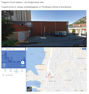
When finally, a two story building clad in rust-coloured corrugated iron catches my eye, because there's a garage jutting out towards the road just the way I remember it.
Could this be it?
Then I notice the hulking grey building next door.
Yeah, this could be it.
I zoom in.
The wall of the garage is grey – and blank – and it's right next to the road. I immediately recognise it from the photos I took that night.
Truganini's not there to reassure me, but this Street View image could be years old. This. is. definitely. the spot.
Screen shot.
Switch back to the normal map – screen shot.
Switch to Satellite View – screen shot.
Fist pump.
I've got the location – for sure, done. And then I notice, on both map views, it seems to be indicating that the building I have pin-pointed is tagged as Bergen Arkitekthøgskole.
I quickly search that online: The Bergen School of Architecture. Interesting! Now I've got the location and a lead.

Is this what fame feels like? Online Facebook fame? Micro-fame? Is there such a thing as micro-fame? Or is that an oxymoron? Am I the moron for feeling it as fame at all? This mural has caught people's attention not because of me, but because of its mystery; its out-of-place-ness; its other(-side-of-the-)worldliness.
And ABC radio want to interview me! Is this what viral means? Is this what news is? Me posting a few photos of street art I stumbled upon in Norway 2 months ago when I'm back home trying to sketch out a new life for myself and the kids?
Why-why-why? All these whys don't make me wise. All I know is that I hold this story, and it feels like a gift. And I feel a responsibility to find the next chapter; to write it down; to share it. And it feels good to have a project; something to drive me on, it gives me a momentum to carry me through my grief.
So here I am...
Desperately trying to remember that ride I took – zooming here, there and everywhere using the simple old-school technology of a pushbike; and tryin' to match that ride to the map of Bergen I'm zooming in and out using the nifty online technology of Google Maps.
I remember...
the air: so freshly born of the sea it still had seaweed hanging off the fringe of every gust; and so sharp it sliced through my travel weariness like a broad sword through brunost.
I remember the measured breaths; the rhythmic pulse of pedals and the whistling melody of wind playing every bit of me and my bike like a jazz percussionist.
I remember being struck by the strangeness of everything: the light fittings above doorways; the camber of ship bows; the slope of house roofs; the curve of street gutters; and even riding itself – me, a fleshy body, balanced on a metal frame all geared and cogged with rubber-hugged wheels.
I remember suddenly feeling like I was running, with strange rounded steps, just above the ground; the bike, an invisible staircase; and the pedals, two little stairs that I could never step over, no matter how fast I ran.
I remember setting out from just outside that beautiful stretch of colourful old wharf buildings at Bryggen, and following the road down along the dock past boats and boat-buildings, and there was a park on my right.
From the broader Bergen map I zoom in to Bryggen. I see the park.
And I remember sweeping round to the right, jumping the curb like a BMX-er from the 80s.
Google Maps isn't giving me a name for this street, just a number – 585.
I'm pretty sure I just followed this road for a k or two. Gliding along with a fluid sense of freedom, I'm sure my face was an emblem of dumb wonder.
I remember, after seven days of travel – from Melbourne to Bergen – guided, controlled and steered by others (two flights; eleven trains; three buses; two ferries and a taxi), that simple blue-trimmed pushbike was my very own visceral, literal conveyor of freedom!
After all those travelators and elevators and escalators it felt like, suddenly, all of Bergen was my backyard! And this 'greener grass' was covered with Slip-n-slides all hosed-down and bubbled-up for me to slip into a cycling serenity and slide into sweeping smiles under my own muscle-powered momentum.
And there was a bonus that sunlit night – in some introductory offer by the city: the bike was free! And it was a double freedom – being free from the heavy weight of the kronor, and free to choose my own path.
I switch from the normal graphic map to Satellite View on Google Maps to see if I can recognise any buildings. But the aspect is too different; nothing stands out, and I'm not sure I trust my memory anyway.
On the map I slowly trace the path of 585 winding up the coast.
I remember the road ultimately rose up and pulled away from the coastline, leading into a road tunnel – that's where, on my bike that night, I turned back.
And there, I can see it on the map – the road disappearing into the mountainside – that's the place.
Truganini must be just back a bit, that's what I remember anyway – heading back down the slope, back towards the city centre – that's where she was.
I didn't see her on the way out because she looked out from a wall perpendicular to the road – facing away from the city.
Okay, time to go to Street View.
I make my best guesstimation for Truganini's location, and drag Google Maps' little yellow man onto that spot.
Suddenly the map turns into a scene of three buildings: a bit industrial and a bit nautical – the right sort of area as I remember it. So I'm vaguely in the right spot. Hopefully. But maybe half of Norway looks like this!
Cumbersomely, I step along the long street, hoping I will actually recognise the building I'm after. Maybe Truganini will even be there – it's not impossible – that would be cool!
If memory serves me correctly, I'm looking for a really large grey building with a garage jutting out towards the road. And I think there was a wire fence to the right.
Exploring the other side of the world with mouse clicks, I press hovering opaque rectangles to move the Street View along. The image sweeps to a new point of view, remains a pixelated blur for a couple of seconds, then sharpens in blocks until the whole image is clear. I do this again and again: click–wait–peruse; click–wait–peruse. And I keep it slow – held back by internet speed, but also, I don't want to miss what I'm looking for just because I'm impatient.
So, it's click–wait–peruse, again and again. My eyes get dry and scratchy. Click–wait–peruse; click–wait–peruse. I'm starting to doubt myself – my memory; the technology; this whole story.
When finally, a two story building clad in rust-coloured corrugated iron catches my eye, because there's a garage jutting out towards the road just the way I remember it.
Could this be it?
Then I notice the hulking grey building next door.
Yeah, this could be it.
I zoom in.
The wall of the garage is grey – and blank – and it's right next to the road. I immediately recognise it from the photos I took that night.
Truganini's not there to reassure me, but this Street View image could be years old. This. is. definitely. the spot.
Screen shot.
Switch back to the normal map – screen shot.
Switch to Satellite View – screen shot.
Fist pump.
I've got the location – for sure, done. And then I notice, on both map views, it seems to be indicating that the building I have pin-pointed is tagged as Bergen Arkitekthøgskole.
I quickly search that online: The Bergen School of Architecture. Interesting! Now I've got the location and a lead.


This is better than AR! - Semmen's detective school, love it.
ReplyDelete